


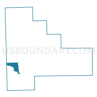
WILMINGTON 2 Voting District, Will County, Illinois
About
Outline

Summary
| Unique Area Identifier | 575596 |
| Name | WILMINGTON 2 Voting District |
| County | Will County |
| State | Illinois |
| Area (square miles) | 11.49 |
| Land Area (square miles) | 10.74 |
| Water Area (square miles) | 0.75 |
| % of Land Area | 93.43 |
| % of Water Area | 6.57 |
| Latitude of the Internal Point | 41.35414440 |
| Longtitude of the Internal Point | -88.18379510 |
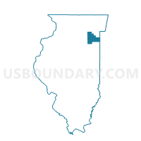
Maps

Graphs
Select a template below for downloading or customizing gragh for WILMINGTON 2 Voting District, Will County, Illinois


Neighbors
Neighoring Voting District (by Name) Neighboring Voting District on the Map
- AUX SABLE 6 Voting District, Grundy County, IL
- CHANNAHON 1 Voting District, Will County, IL
- GOOSE LAKE 2 Voting District, Grundy County, IL
- WILMINGTON 1 Voting District, Will County, IL
- WILMINGTON 3 Voting District, Will County, IL
- WILMINGTON 4 Voting District, Will County, IL
- WILMINGTON 5 Voting District, Will County, IL
Top 10 Neighboring County Subdivision (by Population) Neighboring County Subdivision on the Map
- Aux Sable township, Grundy County, IL (13,061)
- Channahon township, Will County, IL (10,322)
- Wilmington township, Will County, IL (6,193)
- Goose Lake township, Grundy County, IL (1,674)
Top 10 Neighboring Place (by Population) Neighboring Place on the Map
Top 10 Neighboring Elementary School District (by Population) Neighboring Elementary School District on the Map
Top 10 Neighboring Secondary School District (by Population) Neighboring Secondary School District on the Map
Top 10 Neighboring Unified School District (by Population) Neighboring Unified School District on the Map
- Coal City Community Unit School District 1, IL (11,262)
- Wilmington Community Unit School District 209U, IL (9,403)
Top 10 Neighboring State Legislative District Lower Chamber (by Population) Neighboring State Legislative District Lower Chamber on the Map
Top 10 Neighboring State Legislative District Upper Chamber (by Population) Neighboring State Legislative District Upper Chamber on the Map
Top 10 Neighboring 111th Congressional District (by Population) Neighboring 111th Congressional District on the Map
Top 10 Neighboring Census Tract (by Population) Neighboring Census Tract on the Map
- Census Tract 7, Grundy County, IL (6,056)
- Census Tract 8834.01, Will County, IL (4,160)
- Census Tract 8833.06, Will County, IL (3,635)
- Census Tract 8834.02, Will County, IL (2,033)
- Census Tract 9800, Will County, IL (0)